Land & Water Science: First radiometric survey for cherry orchardists
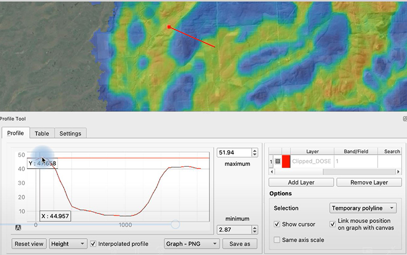
A static image from one of the catchment groups videos which reflects a digital soil map compiled using data points, including radiometric data. The image shows a cross sectional profile which moves (left to right) from predominately gravel soils (shaded yellow), through peat soils (shaded blue). The table/chart reflects the amount of radiation naturally being emitted from the earth. These insights can enable calculations of the depth of peat, and also lead to meaningful calculations of the levels of soil carbon and other elements. Image: Land & Water Science.
Soil is the engine room of any primary industry, yet it is seldom mapped at the type of resolution necessary for farm scale decision-making.
The need for more resolved soil mapping underpins not just farm production, but irrigation and fertiliser use efficiency, soil GHG production and sequestration, and water quality.
Researchers at Land & Water Science have recently completed their first radiometric surveys for several cherry orchardists in Cromwell using their new gamma-ray spectrophotometer.
“The radiometric sensor, plus ground truthing soil samples, are being used to produce high resolution digital soil maps, including soil texture (clay, sand, or silt fractions), carbon, nitrogen, pH, and other chemistry, for the orchard owners as they seek insights on how to optimise their existing water rights, along with deploying water in a more spatially targeted manner to produce larger cherries more consistently across the orchard,” says Director and Principal Scientist Dr Clint Rissmann.
The MS-700 radiometric soil mapping sensor is the creation of Wageningen University (Netherlands) and MEDUSA labs. Clint says they are finding it very versatile as it comes with precision GPS and can be either drone mounted or mounted on the back of an ATV, depending on what is more accessible.
“We can see a lot of uses for this tech, including guiding variable rate irrigation, carbon sequestration assessments, soil suitability mapping, soil drainage mapping, soil fertility mapping, erosion mapping, even mapping wetlands.”
Further Information
Click here for more information about this project and other projects at Land & Water Science.
Date posted: 25 March 2022