Monitoring NZ's road bridges and ports
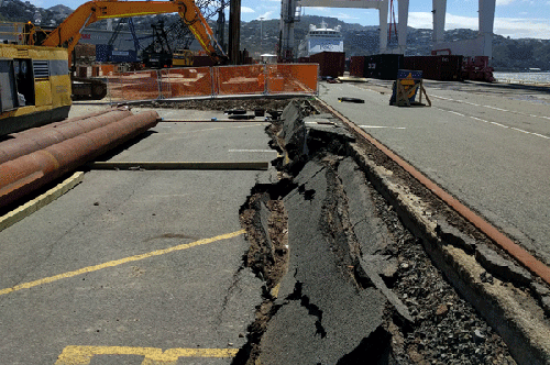
Damage to CentrePort in Wellington following the November 2016 earthquake. Photo: Opus Research.
By Richard Curtis, Business Development Manager, WSP Opus Research
Since 2014, Opus Research has been developing a remote infrastructure monitoring system for the purpose of monitoring the structural integrity of assets anywhere. Initially, we were interested in aging, reinforced-concrete bridges that were past their design lifespans and were carrying traffic volumes and loads far in excess of what they were originally designed for. Monitoring would provide actual data on how a bridge responded to dynamic loading from maximum-weight trucks that could be fed into Finite Element Models which the engineers use in decision-making about bridge structural performance.
Opus Research needed to overcome a number of hurdles in developing the monitoring system. In particular it needed to:
- Be low-cost, as we envisaged it would eventually be used on numerous bridges where asset owners have limited maintenance budgets;
- Have minimal power consumption, as most bridges don’t have mains power, so it would run on batteries and solar recharge;
- Be able to transmit data wirelessly from remote locations, with dataloggers able to be remotely configured; and
- Capture, process and transmit data in real-time, including data from a range of different sensors with vastly different data capture rates, anywhere between 200Hz and once every hour or longer.
Opus Research developed the system over several years, focusing on miniaturisation as part of the quest for low cost and power, bringing the datalogger and battery management system down from something that was originally the size of a small suitcase to that of a shoebox, and a tenth the price.
Since 2014, Opus Research has been monitoring the Rakaia and
Opus Research is now monitoring 12 bridges around
We also monitored the CentrePort wharf in
Date posted: 12 December 2017